 |
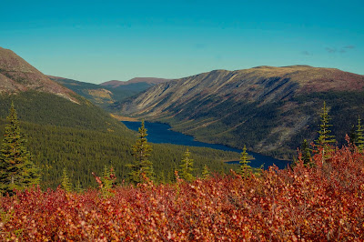
| Shilsky Lake |
In 2012, after a cool spring in southeast Yukon, warmer temperatures arrived in late May and a record snow pack melted fast as rainstorms continued to hit the area. Rivers were rising to flood stage.
On June 8, where the Alaska Highway snakes alongside the Rancheria River and where steep hills border the northeast side, Nature's power struck. Water gushed down the hills, and mud and rock collapsed onto the highway. Rivulets and streams grew in size and strength widening ditches, and spilling stone and wooded debris onto pavement.
 |
| Along the Alaska Highway |
 |
| Flood overflow from Canyon Creek that is behind me. |
In Watson Lake, hotels and campgrounds filled up with travelers, and homeowners opened their doors to stranded tourists.
On the same weekend, four washouts were reported on the Nahanni Range Road north of Watson Lake. Running east from the Robert Campbell Highway, the Nahanni Range Road is a vital link for mines. Contractors rushed to install temporary bridges.
 |
| Dolly Varden Creek - one culvert missing |
 |
| Where damaged culvert came to rest on Dolly Varden Creek |
The rivers and creeks returned to normal water levels. Road and bridge repairs continued throughout the summer; however, a reminder of the flood's strength remained on the shores of the Liard River. At Whirlpool Canyon, a few miles east of Fireside, British Columbia there sits an enormous graveyard of trees piled and shoved together. Their bark peeled by the force of the river and submerged rocks.
For one brief time, Nature had shown her power and we were humbled.

Hi Susan. Your blog posts are so interesting ... I just love the photographs and the commentary that goes with them. How is your novel going? We haven't caught up for a while.
ReplyDelete